Re-imagining Headington’s roads and junctions
Anyone who cycles, walks or wheels around Headington knows how difficult and dangerous it can be, and feels, on our local roads, and experiences how our roads seem designed to prioritise people driving over everyone else.
This car-centric design is clear every time you can’t use a bike lane because cars are parked in it; every time you can’t access a ‘bike box’ because cars are pulled up in it; every time you use a junction by bike and can’t work out how to cross safely; and, as a walker or wheeler, every time you wait ages (twice) to cross the London Road-Windmill Road junction in Headington centre; every time the pedestrian crossing point on Headley Way junction is submerged by a huge puddle of water; and so on. (See our earlier post linking to a study and film about ‘Motornormativity’ for more on this.)
Our other previous posts, “Spotlight on school travel: no safe routes to school for children in Headington” Part 1 and Part 2 looked at the lack of good active travel infrastructure in Headington, how Headington compares unfavourably with other parts of Oxford and why it is so poor for people walking, cycling and wheeling here.
But it doesn’t have to be this way. Other countries in Europe – the Netherlands in particular, but also cities like Ghent, Groningen, Copenhagen, Olou, Helsinki, Paris, Seville, Belgium – have redesigned their roads to make it easy and safe to get round using non-car methods. Other UK cities, such as Cambridge, Coventry, Cardiff, Chorlton, Brighton, Bolton, Manchester and Sheffield, have been making changes to their roads, too, with London taking a lead in active travel provision, for example in:
When you look at what other cities are doing, you can see how far behind Oxford – and particularly Headington – is. We want to change this. We want to get high-quality, best-practice, example-setting active travel infrastructure built in Headington so that everyone can walk, wheel and cycle here safely and easily.
Unfortunately, Oxfordshire County Council, which is responsible for our roads, doesn’t seem to have the will or ability to provide active travel infrastructure in line with current guidance. This is clear from the poor standard of cycling and pedestrian provision in Headington built under the Council’s flagship “Access to Headington” scheme, the Council’s failure to install the Headington low-traffic neighbourhoods it received funding for and its recent abandonment of transformative plans for Woodstock Road, as explained in this Oxford Clarion blog – How a visionary scheme became paint on a pavement. The Council currently has no plans for redesigning any of the junctions or roads in Headington.
So it seems that if we want to get changes on Headington’s roads and junctions, we’ll need to get our own visualisations and designs done – to show both the Council and residents what’s required and what’s possible.
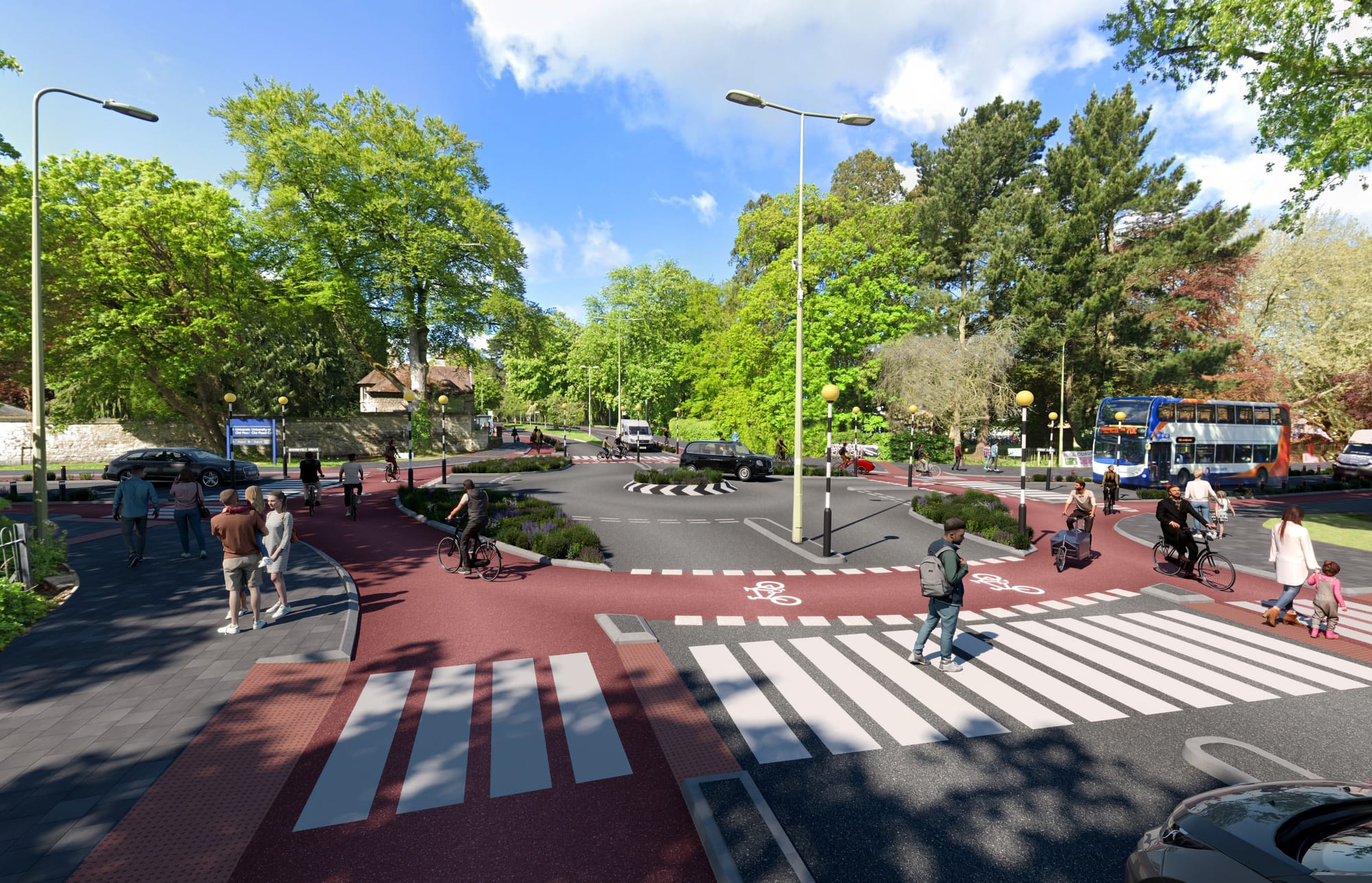
That’s why we asked Infra CGI to create a visualisation of the Gipsy Lane-Old Road-Roosevelt Drive-Warneford Lane junction rebuilt in line with best practice seen elsewhere around the country (see links above for examples).
We chose to prioritise this junction initially because:
- It is right outside Cheney School and used by hundreds of children walking and cyling to school.
- It is the entrance to several university and hospital sites via Roosevelt Drive: Warneford Hospital, Churchill Hospital, Old Road Campus and Headington Care Home and used by 1000s of healthcare workers, researchers, academics, patients and visitors.
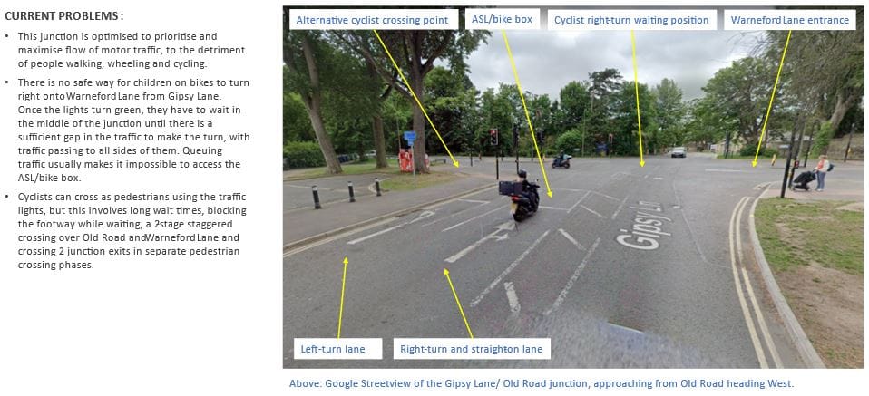
- Currently it is a horrible junction to navigate by walking, cycling, wheelchair or mobility scooter, with long wait times to cross (and in the case of Warneford Lane and Old Road having to cross in two stages via precarious narrow strips), tight obstructed pedestrian islands and no safe way of turning right by bike. The Access to Headington changes prioritised motor traffic by building a new lane to exit from Roosevelt Drive, increasing the length of the approach lane on Old Road and creating staggered right-angle pedestrian islands where before they were straight crossings with no turns. (Compare before and after images below.)
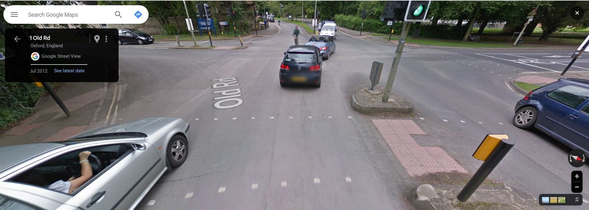
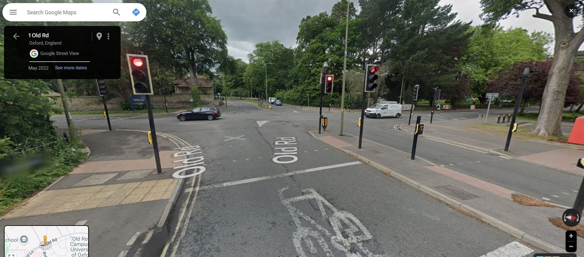
The pedestrian crossing on Old Road before and after Access to Headington changes. The new crossings are very difficult, if not impossible, for people using wheelchairs, mobility scooters, pushchairs or cycles to use due to the tight 90 degree turns, obstructive signal poles and lack of space.
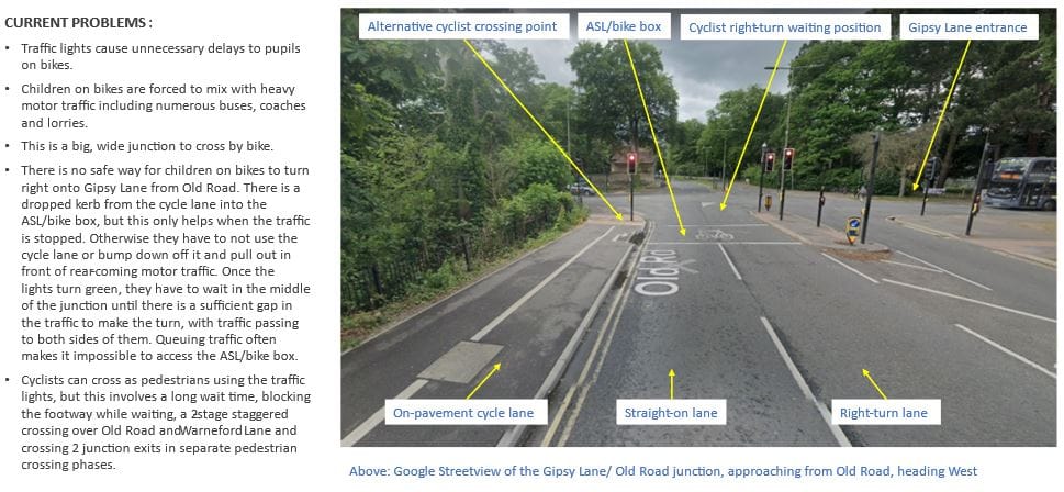
The slides below set out the current problems with this junction in more detail, from the perspective of children cycling to/from Cheney School.
How this design benefits people walking, wheeling and cycling
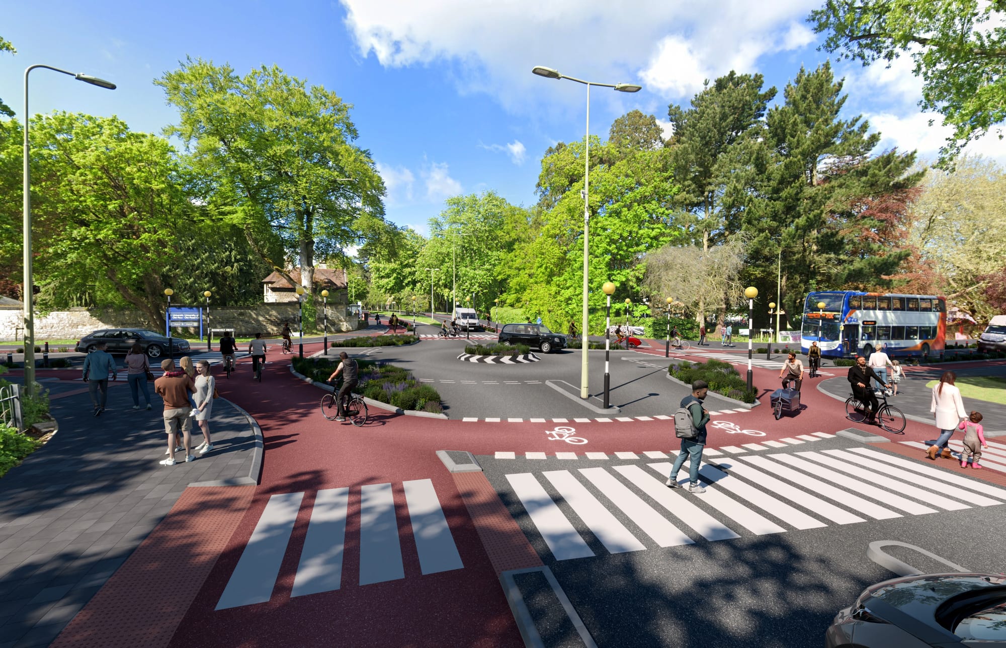
The above design – known as a CYCLOPS junction, or ‘Dutch roundabout’, and seen in a growing number of locations around the country (find out how they work at the bottom of this post) – aims to improve safety and convenience and give priority for people walking, wheeling and cycling, in the following ways:
- The central roundabout, narrowed carriageways and tighter turns into the road entrances force drivers to slow down, creating a safer junction through lower speeds.
- The two-lane exits for motor vehicles have been reduced to single-lane exits, with the space previously used for the second lanes re-allocated to create protected cycle lanes instead.
- The use of zebra crossings means that drivers have to yield/give way to people walking, wheeling or cycling, and those ‘active travellers’ don’t need to push a ‘beg button’ or wait to cross, shifting priority from drivers to non-drivers.
- Cyclists have to yield/give way to people walking and wheeling, reflecting the Council’s transport user hierarchy with people walking and wheeling at the top, followed by cyclists.
- Clear separate provision for cyclists and pedestrians shown by road markings, coloured tarmac and kerbs removes conflict and reduces collision risks between those groups.
- The pedestrian crossings are straight, single-stage and shorter.
- Cyclists are protected from motor vehicles by raised kerbs and the planted ‘buffers’ you can see on each rounded corner – this of course also protects pavement users, for whom the cycle lane acts as an additional buffer, creating greater distance between pavement users and cars.
- The lack of timed signalised crossing phases will eliminate the practice of drivers speeding up to ‘catch the green light’, removing that source of danger for active travellers.
This design should also benefit drivers with fewer delays: without signalised crossing phases, there will be no arbitrary waiting periods – if there are no pedestrians/wheelers/cyclists crossing at the time, drivers can proceed straight through the junction.
We’ve included some links at the bottom of this page to help explain how this type of junction works.
Can you help us re-design Headington?
We would like to obtain re-designs for all the main roads and junctions in Headington – both 3D visualisations like this one and, eventually, 2D preliminary engineering designs.
These visualisations by Infra CGI cost £600 per junction, which reflects a 50% discount for voluntary/non-profit groups like us. We’ve been in discussions with engineering firm Royal Haskoning, which designed the Dutch roundabout in Cambridge and worked with the BikeSafe charity in Oxford to produce designs for a protected cycle track along the B4044 (Farmoor Road). They have quoted a rough figure of £5,000 per junction/road corridor to produce concept designs.
Which Headington junction do you think the new designs should prioritise? Let us know at hello@headingtonliveablestreets.org.uk and copy in your local councillors if you want to let them know you want safer roads too!
Headington Liveable Streets is run entirely by local volunteers. We’re seeking grant funding from various organisations but were unfortunately turned down for CIL funding by Headington Action last year. Whilst we’ll continue to pursue grant funding opportunities, we’ve set up a crowdfunding campaign using the ko-fi platform and Stripe payments so that people who have an interest in this can make a donation.
If you’d like to contribute to the junction design fund, please visit our ko-fi page or use the form below, letting us know in the “Your message” box which Headington junction(s) you think should be prioritised.
If you or someone you know might be able to contribute some design work free of charge or at a reasonable rate reflecting our voluntary/non-profit status, please get in touch at hello@headingtonliveablestreets.org.uk.
Here are some links that may help explain how Dutch roundabouts work:
- Video explainer of a Dutch-style intersection (in French but the visuals are self-explanatory!)
- Cycle cam footage of using the Cambridge Dutch roundabout
- Photos of the Cambridge Dutch roundabout
- A more detailed, technical analysis of the Cambridge Dutch roundabout by Ranty Highwayman
- CamCycle YouTube video of the Cambridge Dutch roundabout in action
- YouTube video explainer of the Cambridge Dutch-style roundabout
- YouTube video explainer of the Sheffield Dutch-style roundabout
If you want to see more examples of good active travel infrastructure, have a look at these links:
- Dutch Cycling Embassy website, X account and Bluesky account
- Infra CGI website and X account
- Modacitylife X account and related Linked accounts here and here
